
Clear height, as several numbers
Underside of roof deck, underside of the beams, and the underside of open steel web joists all sit at different elevations. Quoting one number is how disagreements start, so each is recorded separately.

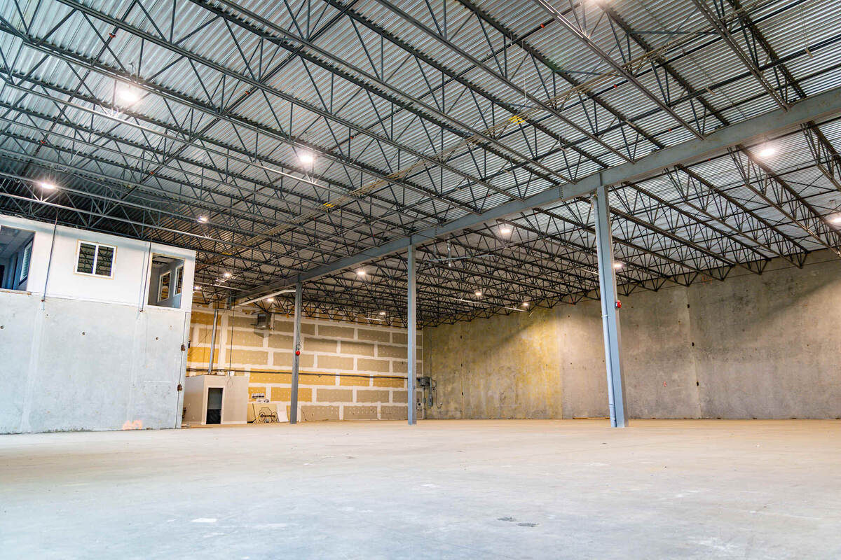
Warehouse, Distribution & Industrial · Metro Vancouver
An industrial building is bought, leased and fitted out on numbers that a floor plan alone does not carry — clear height under the structure, the spacing of the columns, how the dock doors sit against the slab. We scan warehouse, distribution and manufacturing space in LiDAR and deliver measured as-built floor plans that answer those questions without sending anyone back to site.
Ask what a tenant needs to know about an office suite and the answers are largely flat: how much area, where the walls run, how the floor divides. Ask the same question about a warehouse and almost every answer points upward. How high can racking go before it meets the structure. Whether a mezzanine will clear the door beneath it. Where the beams sit relative to the aisles somebody is about to lay out.
That is the part conventional documentation handles worst. A legacy drawing set will usually give a footprint and a room list, and then go quiet exactly where the money is. Heights get reduced to a single nominal figure or omitted altogether. Column positions get drawn on a nominal grid rather than measured where they actually stand. Dock doors appear as symbols with no dimension attached.
The other problem is distance. A distribution floor runs continuously for a long way, and a tape run over that distance accumulates error at every hand-off. On a 12,000 square foot clear-span floor, small repeated inaccuracies compound into a total area figure nobody can defend and a column grid that drifts as it crosses the building. LiDAR does not accumulate error the same way, because every point is measured against the same survey rather than against the last measurement taken.
An as-built survey of a warehouse is therefore less about redrawing the plan and more about recording the things the plan never held in the first place.
An industrial as-built floor plan is a drawing of the building as it stands today, made from measurements taken on site rather than copied from the original construction set. For a warehouse, distribution or manufacturing building that means walls, columns, doors, overhead doors and stairs located where they actually are, with heights, mezzanines and the front office added as the scope requires.
Most people searching for one already have a question they need it to answer. Will the racking fit. Where can the aisles go. Can a mezzanine be added. How much area is actually being leased. The plan is only worth commissioning if it carries the measurement that settles that question, so it is worth knowing which part of the drawing does the work before the scope is agreed.
The table below sets out the questions an industrial floor plan is usually asked to answer, the part of the measured set that answers each one, and who makes the final call. That last column matters: a floor plan gives everyone the same measured basis, but it does not decide what a racking system, a mezzanine or a lease is allowed to be.
Bring the question to the scoping conversation and the package follows from it.
| The question | What the measured set gives you | Who makes the call |
|---|---|---|
The questionHow high can racking go? | What the measured set gives youUnderside of roof deck, underside of the beams and underside of the joists, each recorded as its own elevation. Heights are part of Shell 360 and Full 360. | Who makes the callThe tenant's fire protection consultant, engineer and the authority having jurisdiction. |
The questionWhere can the aisles run? | What the measured set gives youEvery column located where it actually stands, so bay spacing comes straight off the drawing. Columns are on the plan in every package, including Base 360. | Who makes the callThe tenant and whoever is laying out the racking. |
The questionWill our trucks and loading fit? | What the measured set gives youDock and overhead door positions, widths and heights, with dock and grade-level access shown and the apron in front recorded. | Who makes the callThe tenant, against their own fleet and handling equipment. |
The questionCan we add a mezzanine, or use the one that is there? | What the measured set gives youExisting mezzanine area, headroom above and below, and stair and access positions, plus the structure elevations a new one would be framed against. | Who makes the callThe tenant's designer and structural engineer, and the authority having jurisdiction. |
The questionHow much area is being leased? | What the measured set gives youA measured floor plan the area is calculated from. Area to a published standard is a separate deliverable, because the lease decides which standard applies. | Who makes the callThe landlord and tenant, under the terms of the lease. |
The questionWhere can new equipment go? | What the measured set gives youPits, trenches, drains, housekeeping pads and slab level changes as measured geometry, with visible overhead services captured in the same pass. | Who makes the callThe process engineer planning the layout. |
We measure and draw. What any installation, alteration or lease figure is required to be is decided by the people in the last column.
These are the items that decide whether the drawing set survives contact with a real tenant enquiry.
Underside of roof deck, underside of the beams, and the underside of open steel web joists all sit at different elevations. Quoting one number is how disagreements start, so each is recorded separately.
Bay spacing governs racking layout, drive aisles and how a mezzanine can be framed. Columns get located where they actually stand, not on the nominal grid an old drawing assumed.
Door positions, widths and heights, dock versus grade-level access, and the ramp or apron in front of them. A tenant's fleet either fits this or it does not.
Area above, headroom below, stair and access positions. Mezzanines are frequently the least documented part of an industrial building and the most often altered.
The finished front-of-house portion is measured to the same standard as the warehouse floor, with its own ceiling heights, so the two can be reported separately or together.
Visible mechanical, electrical, lighting and sprinkler distribution are captured in the same pass, which is what makes the record useful to a fit-out rather than only to a listing.
Figures from our LiDAR survey of a single-storey office and warehouse building on Holt Road in Surrey, scanned for the Cushman & Wakefield listing team. Every number was measured, not taken from an existing drawing.
The site work is a single visit with one operator. Nothing needs to be powered down and operations do not have to stop.
Warehouse floor, office area, mezzanines, dock and yard as required — plus which areas need a safety escort, high-vis, or a time of day that avoids shipping and receiving.
The iGUIDE PLANIX is tripod-mounted and moves through the building one setup at a time, capturing LiDAR geometry and 360° imagery together. Large clear-span areas cover quickly; compartmented office and service space takes more positions per square foot.
Deck, beam and joist elevations are taken as separate measurements rather than inferred from a single ceiling reading, and mezzanine clearances are recorded above and below.
Plans are drawn from the point cloud, not traced from an older set. Where a legacy drawing disagrees with what was measured, the measurement governs and the difference is flagged rather than quietly reconciled.
PDF plans and a walkable 3D tour first, DWG for the drafting team, and a Revit model where the project runs in BIM.
Our own scanning work and delivered industrial photography.
The right level of detail depends on what the drawings have to carry. Cost tracks floor area and scope, and the booking tool prices it instantly.
Area calculation to a published standard is a separate deliverable, because which standard applies depends on the lease rather than on the scan.
Vacant space scans faster and produces a cleaner dataset, and where a building is between tenants that is the moment worth taking. Most industrial documentation, though, happens in a building that is still running, and that is a scheduling question rather than an obstacle.
The scanner is tripod-mounted and moved by a single operator on foot, so there is no cabling to run and nothing to power down. Racking, palletised stock and equipment are scanned around; what sits behind a full rack is recorded as far as it is visible, and anything obscured is flagged rather than guessed at. Where forklift traffic makes open-floor work awkward, we work around shipping and receiving or scan outside operating hours.
Site safety runs on the building's terms — high-vis, boots, escort, induction, whatever the operator or occupier requires. It is worth raising these constraints when the scope is agreed rather than on the morning of the visit, because access is almost always the thing that determines how long a warehouse takes, not floor area.
Storage and distribution is the most common industrial use, but it is not the only one, and a manufacturing or process building asks a different set of questions of its drawings. The building envelope may be identical to the warehouse next door while everything that matters inside it is different.
What changes is that the equipment becomes part of the building. Machinery sits on the slab in a fixed position and is fed by services run to it — power drops, compressed air, process piping, extraction — and those runs are rarely on any drawing at all, because they were installed by whoever commissioned the equipment rather than by whoever built the building. Where a line runs, and what it clears overhead, is exactly the thing a layout change needs to know.
The floor itself carries more information too. Pits, trenches, drains, housekeeping pads and changes in slab level are permanent features that a nominal plan flattens into nothing, and they are the first constraint on where a new machine can go. Captured as measured geometry, they become something a process engineer can lay out against directly.
The same applies across multi-tenant industrial parks, where several units of different sizes and uses sit under one roof. Documenting each unit through the same capture method and the same drafting conventions is what makes industrial as-built floor plans comparable across a site — usable areas that can be stacked, demising lines that agree with each other, and one measurement standard rather than a folder of drawings made by different hands at different times.
Leasing agents and landlords use it to market the building with numbers that hold up under questioning. A prospective tenant asking about clear height, dock count or usable area gets an answer the same day instead of a site visit, and the floor plan they are sent matches the building they walk through.
Tenants and their consultants use it to plan what goes inside — racking runs and aisle widths against the real column grid, a mezzanine against the real headroom, process equipment against the real structure overhead.
General contractors use it to price and to establish the existing condition before work starts, particularly on office build-outs at the front of an industrial building where the finished area and the warehouse meet.
Property managers and asset teams use it as the current building record, and gain more from it across a portfolio than on any single building: consistent measurement across every property is what lets areas be compared and stacked without reconciling three different survey methods.
The Holt Road project is a real Surrey office and warehouse building we scanned and delivered — measured areas, three clear heights, floor plans and the data behind them.
Opens the project page on this site.
We have multiple warehouses that need to be leased out from time to time. For our most recent listing, we engaged PlanBase 360 to come in and generate accurate measurements for all the rooms and a 3D walkthrough.
This will allow interested parties to take a close look at the location virtually before scheduling a site visit.
The granularity of the measurements will also allow prospects to imagine how their business will fit into their new space.
The PlanBase team was excellent. They were in and out in no time and I had all my deliverables the next day.
Will definitely use them again.

Mark Sippola
Local Guide
It is a floor plan of an industrial building as it exists now, drawn from measurements taken on site rather than traced from the original drawings. We scan the building in LiDAR and draft walls, columns, doors, overhead doors and stairs from the measured data, then add clear heights, mezzanines, the office area and visible services as the scope requires. It is delivered as PDF plans and a 3D tour, with DWG and Revit where the team needs them.
Yes. The elevations are derived from the LiDAR capture taken from floor level, so no lift, ladder or fall protection is involved in getting them. Deck, beam and joist heights are recorded as separate figures rather than a single ceiling number, because in an industrial building those three elevations rarely agree and different installations answer to different ones.
No. An empty building scans faster and gives a cleaner dataset, so if the space is already vacant that is the ideal moment, but most industrial scans happen in a working building. Racking and stored goods are scanned around, and anything genuinely obscured is flagged rather than estimated. Where forklift traffic is heavy we work around shipping and receiving or scan outside operating hours.
Yes. Columns are located from the measured data where they actually stand rather than placed on a nominal grid, which is the point of the exercise for anyone laying out racking or aisles. Bay dimensions come off the same drawing, and the CAD file lets a tenant or consultant test a layout directly against it.
Yes, and it is worth asking for explicitly, because mezzanines are frequently the least documented part of an industrial building and the most often altered without any record. We capture the mezzanine area and the headroom both above it and beneath it, along with stair and access positions.
Usually a single visit. A large clear-span floor covers quickly, while the finished office, washrooms and service rooms at the front take more scan positions per square foot than the warehouse itself. Floor plans and the 3D tour follow in one to two business days, with CAD and BIM within about a week.
No, and you should be careful of anyone who does. Requirements depend on the occupancy, the commodity being stored, the fire protection system and the authority having jurisdiction, so that determination belongs with your fire protection consultant, engineer and the local authority. What we provide is the measured basis they all work from: accurate structure elevations, real column positions and a floor plan that matches the building.
Book the scan online with an instant estimate. Plans and the 3D tour in one to two business days, CAD and BIM within the week.